
What is a Crest Level
Crest level is the elevation of the top edge of a weir, spillway or overflow structure over which water begins to pass when the upstream water level rises sufficiently. In drainage and hydraulic engineering, it is a key design parameter used to control when overflow occurs, how water is distributed between different routes and how much temporary storage is available before discharge begins.
The crest level is normally expressed as an elevation relative to a defined datum, such as metres above Ordnance Datum (m AOD) in the UK. It is particularly important in stormwater attenuation systems, combined sewer overflows, detention basins and flood control structures. Even a relatively small difference in crest elevation can change when a structure starts to discharge and how frequently an overflow operates.
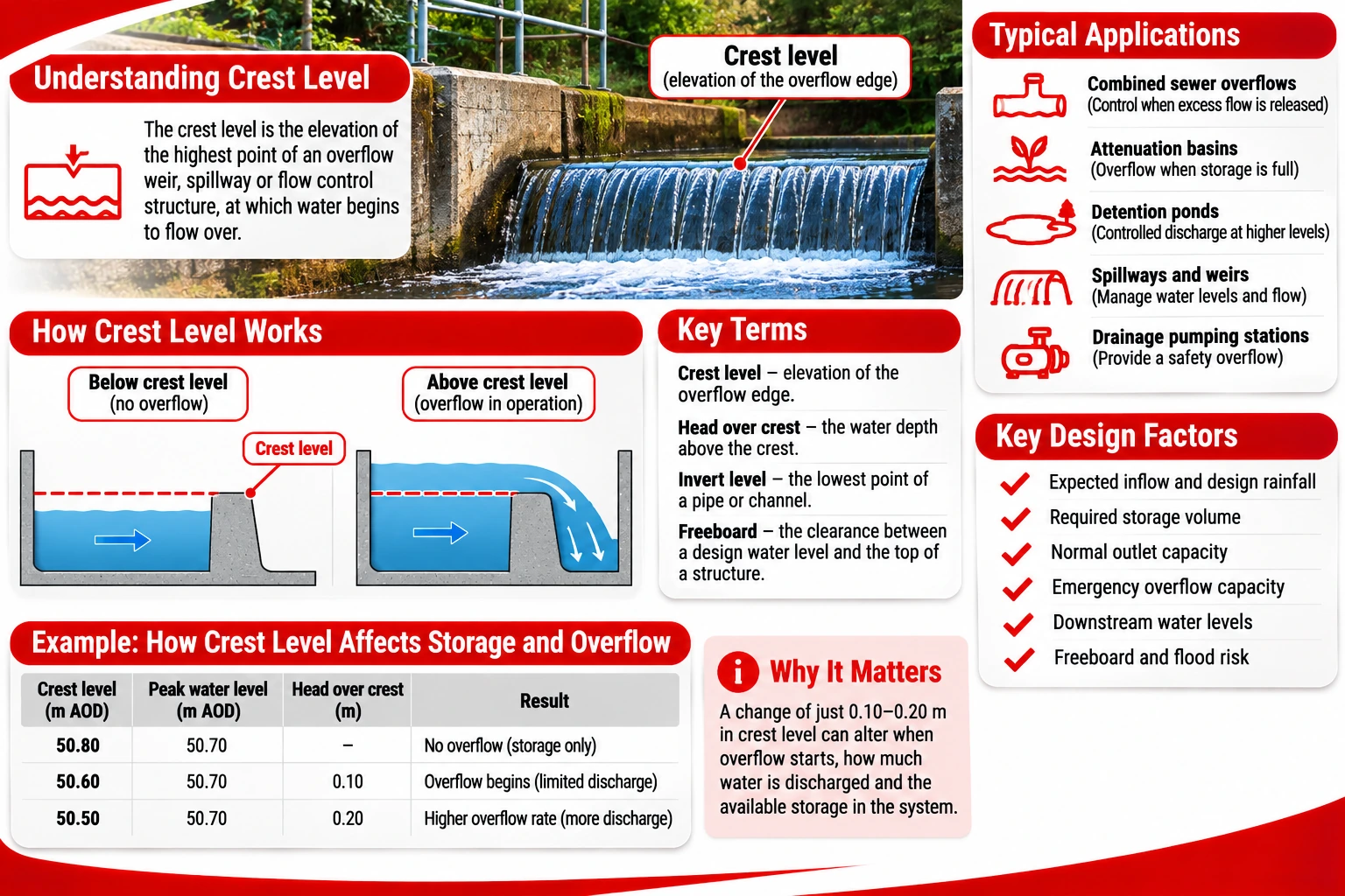
What Does Crest Level Mean in Drainage Engineering?
A crest is the upper edge or controlling surface of a hydraulic structure over which water flows. Its level establishes a reference point for assessing the upstream water depth required for overflow.
For a simple horizontal overflow weir, water begins to pass over the crest when the upstream water surface rises above its elevation, provided downstream conditions allow discharge. As the upstream water level increases, the depth of water above the crest increases and the discharge generally rises.
The distinction between crest level and other drainage elevations is important:
| Hydraulic term | Meaning | Typical application |
|---|---|---|
| Crest level | Elevation of the controlling overflow edge | Weirs, spillways and overflow chambers |
| Invert level | Elevation of the lowest internal point of a pipe or channel | Gravity drains and sewers |
| Water level | Elevation of the water surface at a particular time | Hydraulic monitoring and modelling |
| Head over crest | Vertical difference between the upstream water level and the crest reference | Weir discharge calculations |
| Top water level | Specified upper water level used in the design or operation of a storage system | Attenuation ponds and reservoirs |
| Freeboard | Vertical clearance between a specified water level and the top of a containing structure | Flood protection and storage design |
These values serve different purposes. An invert level determines the low point of a pipe or channel, while a crest level determines the elevation at which water can pass over a particular overflow control.
For example, consider a drainage chamber with a weir crest at 25.40 m AOD. If the upstream water surface reaches 25.65 m AOD, the water level is 250 mm above the crest. This difference represents the upstream head over the crest, although the effective hydraulic head used in detailed calculations may also depend on approach velocity and other conditions.
A crest level should always be recorded with its reference datum. A value of 25.40 m has little engineering meaning unless the drawing or specification identifies what the elevation is measured from.
How Crest Level Controls Water Flow
The primary function of a crest level is to establish when an overflow route becomes active. In a drainage system with multiple flow paths, the crest may allow ordinary flows to continue along one route while directing excess water into another channel or storage area during higher-flow conditions.
This principle is used in stormwater management and combined sewer systems. A weir can help control the division of flow between a downstream sewer and an overflow route, although the actual operating behaviour also depends on the geometry of the chamber, downstream water levels and other hydraulic controls.
The relationship between crest elevation and discharge is influenced by several factors:
-
Upstream water level. Greater water depth above the crest generally produces higher discharge.
-
Crest length. A longer effective overflow edge can pass more water under comparable conditions.
-
Crest shape. Sharp-crested, broad-crested and specially profiled weirs have different hydraulic characteristics.
-
Downstream water level. High tailwater can submerge the weir and alter its discharge behaviour.
-
Approach conditions. Flow velocity, turbulence and chamber geometry affect the hydraulic performance.
-
Obstructions. Debris or sediment around the crest can change the effective opening and flow conditions.
For a conventional free-flowing rectangular weir, discharge is related to the effective crest length and the head above the crest. Under suitable assumptions, discharge increases approximately with the head raised to the power of 1.5. The coefficient used in the calculation depends on the weir geometry and hydraulic conditions.
This relationship explains why relatively small changes in upstream water depth can produce substantial changes in discharge. However, the same relationship cannot be applied indiscriminately to submerged weirs, irregular openings or other types of flow control.
Crest level is also important when assessing surcharge conditions. If downstream water levels rise sufficiently, they may affect the ability of water to pass over the crest. A structure designed to operate under free-flow conditions may behave differently when submerged.
Where Are Crest Levels Used?
Crest levels are relevant wherever water must pass over a defined hydraulic boundary. Their purpose varies according to whether the system is designed to divert flow, control storage or provide emergency overflow capacity.
Common applications include:
-
Combined sewer overflow chambers. A crest establishes the level at which flow can enter an overflow route, although operation also depends on the complete hydraulic arrangement.
-
Stormwater attenuation basins. An overflow crest can provide a controlled route for water when storage levels exceed the intended operating range.
-
Detention ponds. Spillway crest elevations influence when stored water can leave through an overflow structure.
-
Open-channel weirs. Crest levels are used to control upstream water levels and, in suitable arrangements, measure discharge.
-
Flood relief structures. Spillways and overflow channels use defined elevations to direct water during high-flow events.
-
Drainage pumping installations. Overflow arrangements may include a crest or overflow opening that limits water levels under specified conditions.
In attenuation systems, it is important to distinguish the normal outlet control from an emergency overflow. The normal outlet may be an orifice, vortex flow control or other device that restricts discharge. An emergency spillway can provide an additional route when the stored water rises beyond a specified level.
The emergency overflow crest must be coordinated with the storage volume, maximum design water level and available freeboard. If it is set too low, the system may discharge through the emergency route more frequently than intended. If it is too high, the stored water may reach an unacceptable level before overflow begins.
Crest level also affects how a storage system performs during consecutive rainfall events. If water remains in the system from an earlier storm, less storage may be available before the overflow crest is reached during the next event.
How Is Crest Level Determined in Hydraulic Design?
A crest elevation is selected through hydraulic design rather than by applying a single standard height. The designer must consider the required operating level, expected flows, downstream conditions and the consequences of water exceeding the intended storage or conveyance capacity.
For a drainage attenuation system, the process usually starts with determining the inflow hydrograph, permitted discharge rate and required storage volume. The designer then assesses how water levels change as the system fills and empties.
The principal design considerations include:
-
Design rainfall and inflow. The expected volume and timing of runoff entering the system.
-
Storage geometry. The relationship between stored volume and water level.
-
Outlet characteristics. The discharge capacity of the normal flow control.
-
Maximum design water level. The highest level expected under the specified design conditions.
-
Emergency overflow capacity. The ability to convey excess water without unacceptable flooding.
-
Downstream restrictions. Potential backwater effects or limited receiving-system capacity.
-
Freeboard and flood routing. The clearance and safe flow paths available if water levels rise beyond the normal operating range.
In England, surface water drainage design may need to demonstrate performance under specified rainfall events, including consideration of climate change allowances where applicable. The relevant criteria depend on the development, planning requirements and drainage authority.
Crest elevations are commonly incorporated into hydraulic models to simulate when overflow begins and how much water passes through the structure. For complex drainage networks, the model may also account for pipe surcharge, downstream water levels and interactions between several control structures.
A simplified example illustrates the effect of changing the crest level.
Suppose an attenuation basin has an emergency overflow crest at 50.80 m AOD. During a particular simulated storm, the water surface reaches 50.70 m AOD. The emergency overflow would not operate under those modelled conditions.
If the crest were lowered to 50.60 m AOD, water could pass over it during the same event, assuming the downstream conditions permit discharge. The change could reduce the peak storage level but would also alter the volume and timing of water released through the overflow.
Neither arrangement is automatically correct. The appropriate crest level depends on the design objectives, downstream flood risk and the overall drainage strategy.
Crest Level, Spillway Level and Flood Risk
Crest level is closely connected with flood risk because it determines when water can escape through a particular overflow route. However, the crest is only one part of the hydraulic system, and it does not by itself establish the maximum water level.
During an extreme rainfall event, inflow may exceed the combined capacity of the normal outlet and overflow structure. Water can then rise above the crest, potentially reaching surrounding ground levels or vulnerable infrastructure.
A properly designed overflow arrangement must consider where discharged water will travel. Providing an overflow opening is insufficient if the receiving route directs water towards buildings, highways or other sensitive areas.
The following distinctions are particularly important:
-
The crest level establishes the elevation of the overflow control.
-
The water level above the crest determines part of the driving head for discharge.
-
The overflow geometry influences how much water can pass.
-
The downstream conditions may restrict discharge or cause submergence.
-
The available freeboard provides additional vertical clearance above the specified water level.
For a broad-crested spillway, the controlling elevation is generally the level of the overflow surface, but detailed hydraulic behaviour depends on the structure’s dimensions and approach conditions. Where the crest is not horizontal, the discharge calculation must account for the actual geometry.
In existing drainage systems, changes to crest elevations can have consequences beyond the immediate structure. Raising a crest may increase upstream water levels and storage, while lowering it may increase the frequency or volume of overflow discharge.
Such changes should therefore be assessed hydraulically rather than treated as minor construction adjustments.
How Are Crest Levels Surveyed and Maintained?
Accurate elevation measurements are essential because hydraulic calculations depend on the actual position of the overflow edge. A discrepancy between the design level and the constructed level can affect the performance of the structure.
Crest levels are commonly established using surveying equipment and recorded against a recognised datum. For UK projects, elevations may be expressed in metres above Ordnance Datum, although local project datums can also be used if clearly defined.
During construction or inspection, the following checks may be required:
-
Verify the crest elevation against the approved design drawings.
-
Check that the crest is level where a horizontal overflow edge is specified.
-
Confirm the effective crest length and relevant dimensions.
-
Inspect for concrete defects, deformation or displaced components.
-
Remove debris or sediment that obstructs the overflow route.
-
Check that downstream channels and discharge routes remain clear.
In some structures, sediment accumulation or debris can effectively raise the level at which water begins to pass. Damage to the crest may have the opposite effect by creating a lower overflow point.
For existing weirs and spillways, inspections should also consider erosion, structural movement and changes to downstream conditions. A crest may retain its original elevation while the hydraulic performance deteriorates because of restrictions elsewhere in the system.
Where the actual crest level differs materially from the design, the effect should be assessed before alteration. Modifying an overflow without understanding the wider drainage network can transfer flood risk to another location.
Crest level is therefore more than a dimension on a drainage drawing. It is a hydraulic control that influences overflow activation, upstream storage and the movement of excess water through a drainage system. Accurate design, surveying and maintenance help ensure that the structure operates as intended under both normal and high-flow conditions.